 |
Astronomy Picture of the Day |
| |
Astronomy Picture of the Day |

|
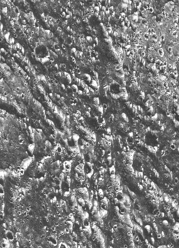
NASA/JPL Press Release Caption: Ridges, grooves, craters and relatively smooth areas in the Uruk Sulcus region of Jupiter's moon Ganymede are shown in this high-resolution image captured by NASA's Galileo spacecraft during its first flyby of Ganymede on June 27, 1996. This image was taken when Galileo was 7,448 kilometers (4,628 miles) away from Ganymede; north is to the top of the picture, and sunlight illuminates the surface from the lower left nearly overhead (77 degrees above the horizon). The area shown, at latitude 10 degrees north, longitude 168 degrees west, is about 55 by 35 kilometers (34 by 25 miles); the smallest features that can be discerned are 74 meters (243 feet). The line-like features are sunlit ridges, often arranged in parallel sets. The patterns of ridges and grooves indicate that extension (pulling apart) and shear (horizontal sliding) have both shaped the icy landscape. |

|
NASA/JPL Press Release Caption: These images demonstrate the dramatic improvement in the resolution of pictures that NASA's Galileo spacecraft is returning compared to previous images of the Jupiter system. The frame at left was taken by the Voyager 2 spacecraft when it flew by in 1979, with a resolution of about 1.3 kilometers (0.8 mile) per pixel. The frame at right showing the same area was captured by Galileo during its first flyby of Ganymede on June 27, 1996; it has a resolution of about 74 meters (243 feet) per pixel, more than 17 times better than that of the Voyager image. In the Voyager frame, line-like bright and dark bands can be seen but their detailed structure and origin are not clear. In the Galileo image, each band is now seen to be composed of many smaller ridges. The structure and shape of the ridges permit scientists to determine their origin and their relation to other terrains, helping to unravel the complex history of the planet-sized moon. In each of these frames, north is to the top, and the sun illuminates the surface from the lower left nearly overhead (about 77 degrees above the horizon). The area shown, at latitude 10 degrees north, 167 degrees west, is about 35 by 55 kilometers (25 by 34 miles). The image was taken June 27 when Galileo was 7,448 kilometers (4,628 miles) away from Ganymede. |

|
NASA/JPL Press Release Caption: A mosaic of four Galileo high-resolution images of the Uruk Sulcus region of Jupiter's moon Ganymede is shown within the context of an image of the region taken by Voyager 2 in 1979. The image shows details of parallel ridges and troughs that are the principal features in the brighter regions of Ganymede. The Galileo frames unveil the fine-scale topography of Ganymede's ice-rich surface, permitting scientists to develop a detailed understanding of the processes that have shaped Ganymede. Resolution of the Galileo images is 74 meters (243 feet) per pixel, while resolution of the Voyager image is 1.3 kilometers (0.8 mile) per pixel. In this view, north is to the top, and the sun illuminates the surface from the lower left nearly overhead. The area shown, at latitude 10 degrees north, longitude 168 degrees west, is about 120 by 110 kilometers (75 by 68 miles) in extent. The image was taken June 27 at a range of 7,448 kilometers (4,628 miles). |

|
NASA/JPL Press Release Caption: A mixture of terrains studded with a large impact crater is shown in this view of the Uruk Sulcus region of Jupiter's moon Ganymede taken by NASA's Galileo spacecraft during its first flyby of the planet-sized moon on June 27, 1996. The image shows fine details of bright areas that make up about half of the surface of Ganymede. Pock-marked, ancient, heavily cratered terrain is seen at the top; it is cut by younger, line-like structures in the lower left of the image. The bright, circular feature in the lower middle is an impact crater with some dark ejecta superimposed on the linear ridges. These types of relationships revealed by Galileo allow scientists to work out the complex geologic history of Ganymede. In this view, north is to the top and the sun illuminates the surface from the lower left nearly overhead. The area shown, at latitude 10 degrees north, longitude 168 degrees west, is about 55 by 35 kilometers (34 by 25 miles), and the smallest features that can be seen are 74 meters in size. The image was taken on June 27 at a range of 7,448 kilometers (4,628 miles). |

|
NASA/JPL Press Release Caption: This view of a part of the Galileo Regio region on Jupiter's moon Ganymede shows fine details of the dark terrain that makes up about half of the surface of the planet-sized moon. One of many ancient impact craters in the region is visible at the middle left. The crater is cut by numerous fractures, showing that the ancient crust was highly deformed early in Ganymede's history. Dark areas may have originated from dark material thrown off by dark meteorites hitting the surface in thousands of impact events. In this view, north is to the top and the sun illuminates the surface from the lower left about 58 degrees above the horizon. The area shown, at latitude 19 degrees north, longitude 149 degrees west, is about 19 by 26 kilometers (12 by 16 miles); resolution is about 80 meters (262 feet) per pixel. The image was taken June 27 at a range of 7,652 kilometers (4,755 miles). |
|
NASA/JPL Press Release Caption: Ancient impact craters shown in this image of Jupiter's moon Ganymede taken by NASA's Galileo spacecraft testify to the great age of the terrain, dating back several billion years. At the margin at the left, half of a 19-kilometer-diameter (12-mile) crater is visible. The dark and bright lines running from lower right to upper left and from top to bottom are deep furrows in the ancient crust of dirty water ice. The origin of the dark material is unknown, but it may be accumulated dark fragments from many meteorites that hit Ganymede. In this view, north is to the top, and the sun illuminates the surface from the lower left about 58 degrees above the horizon. The area shown is part of Ganymede's Galileo Regio region at latitude 18 degrees north, longitude 147 degrees west; it is about 46 by 64 kilometers (29 by 38 miles) in extent. Resolution is about 80 meters (262 feet) per pixel. The image was taken June 27 at a range of 7,563 kilometers (4,700 miles). |